

Sudbury Basin · Ontario, Canada
Brady Sudbury Project
Surrounded by Sudbury's Giants
World-Class Neighbourhood
The 8,811-hectare Brady Project sits on the northeast flank of the Sudbury Basin — near Vale, Glencore and Magna Mining operations, including their 37 Mt (Inferred) Norman West Ni-Cu deposit.† The Brady Sudbury Project lies in close proximity to some of the Sudbury Basin's most significant Ni-Cu-PGM and gold producers.*
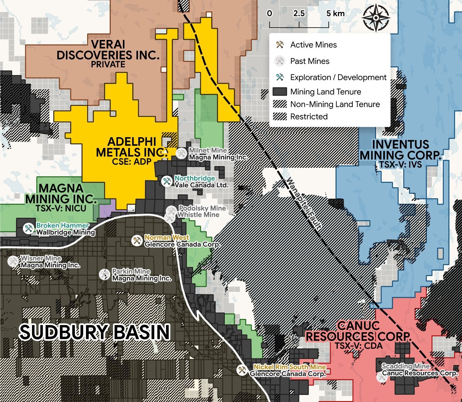 The Brady Sudbury Project within the Sudbury Basin and its neighbouring deposits
Norman West Deposit
37 Mt (Inferred) Ni-Cu-PGM deposit neighbouring the south boundary.†
Podolsky Mine
Home to the 'Yellow Brick Road' — one of Sudbury's highest-grade copper footwall zones.
Whistle & Northbridge
Past producers along the 'Nickel Road' — Brady's access corridor.
*Mineralization on neighbouring or adjacent properties is not necessarily indicative of mineralization on the Brady Project. †Norman West Deposit: 37 Mt Inferred (Geology Ontario, MDI000000003067).
The Driver
A Fault-Controlled Mineral System
The Wanapitei Fault runs the length of the property and projects south into the Scadding gold deposit — a past producer interpreted as an IOCG-style system. Adelphi interprets this fault as the driver of a MIAC mineral system, the structure controlling the gold-copper showings as surface expressions of one fault-driven system.
The Mechanism · One System
-
1
The Fault
The Wanapitei Fault is the master structure, controlling mineralization along its length.
-
2
The Splays
Structures branch off the fault, channelling metals along geological contacts into the surrounding rock (Gold / Copper Showings).
-
3
The Comparable
The Scadding Deposit sits on the same structure to the south — an IOCG-style system in a comparable geological setting.
-
The Opportunity
A coherent mineral system where the biggest target has never been tested.
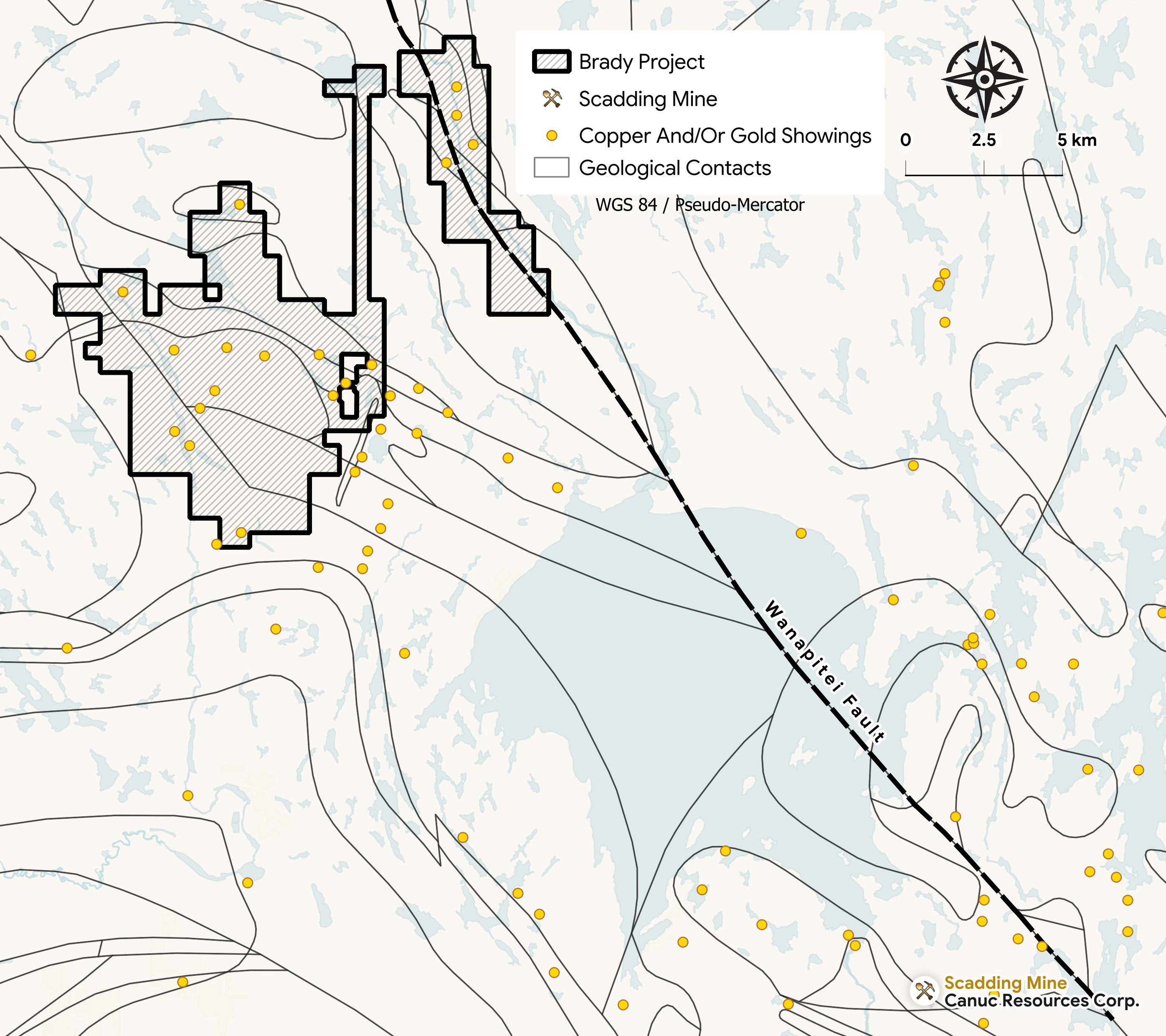 The Wanapitei Fault, projecting south into the Scadding Mine
Exploration Targets
Showings Across the System
River North Target
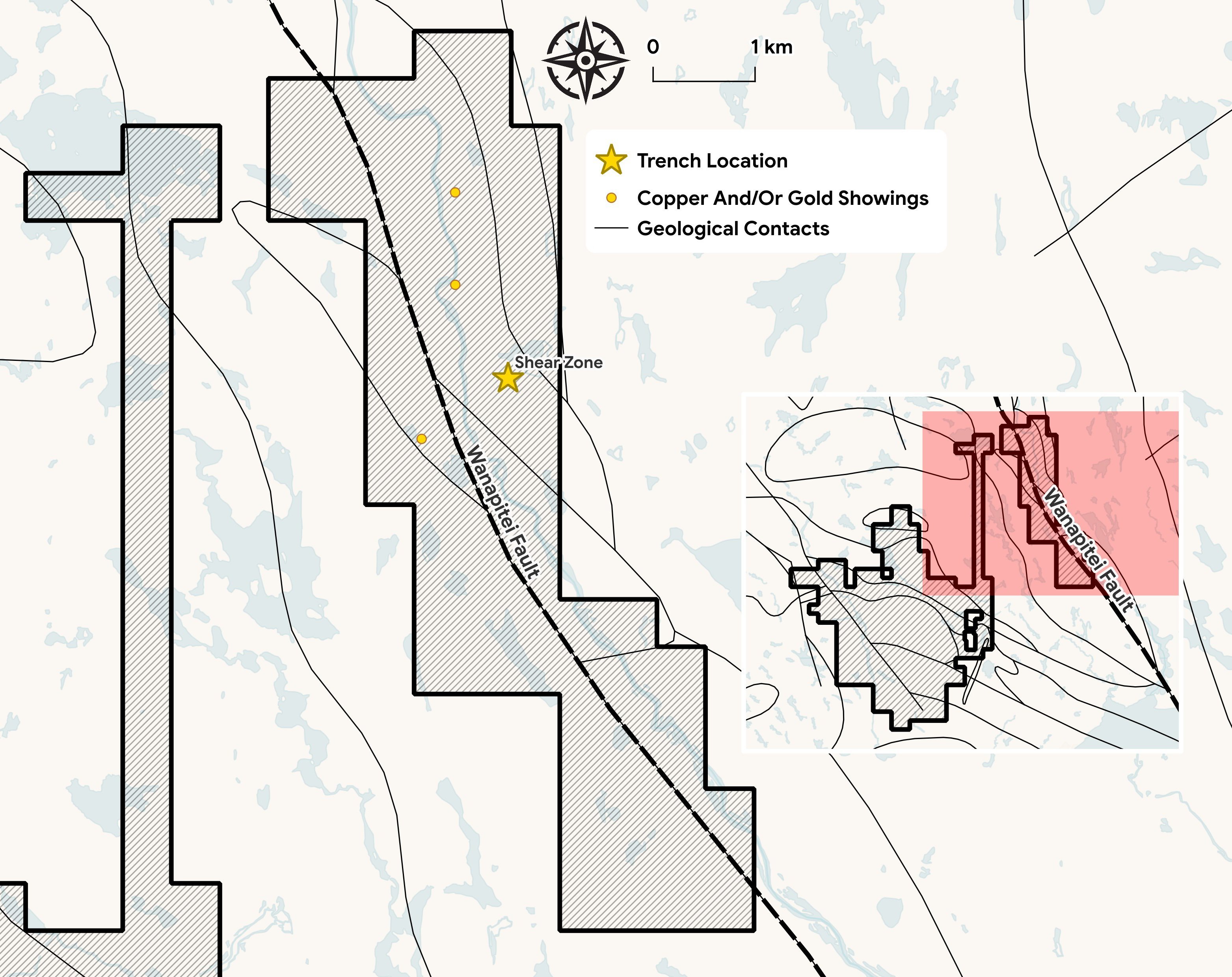
A 6 m shear zone — the Malachite Showing — sits directly on the Wanapitei Fault, where the 2023 trench ended before the mineralization did.
- Iron-rich throughout — Fe to 9.9%, with 2,000–10,000 ppm Cu and 0.5–3 g/t Au. A planned ground gravity survey will test for an iron-rich, IOCG-style body at depth.
- Interpreted as the same structure as the Scadding Deposit — the Wanapitei Fault projects south along the same corridor into Scadding, an IOCG-style past producer.
- No modern drilling has ever been completed on the property.
Gold on the Contact
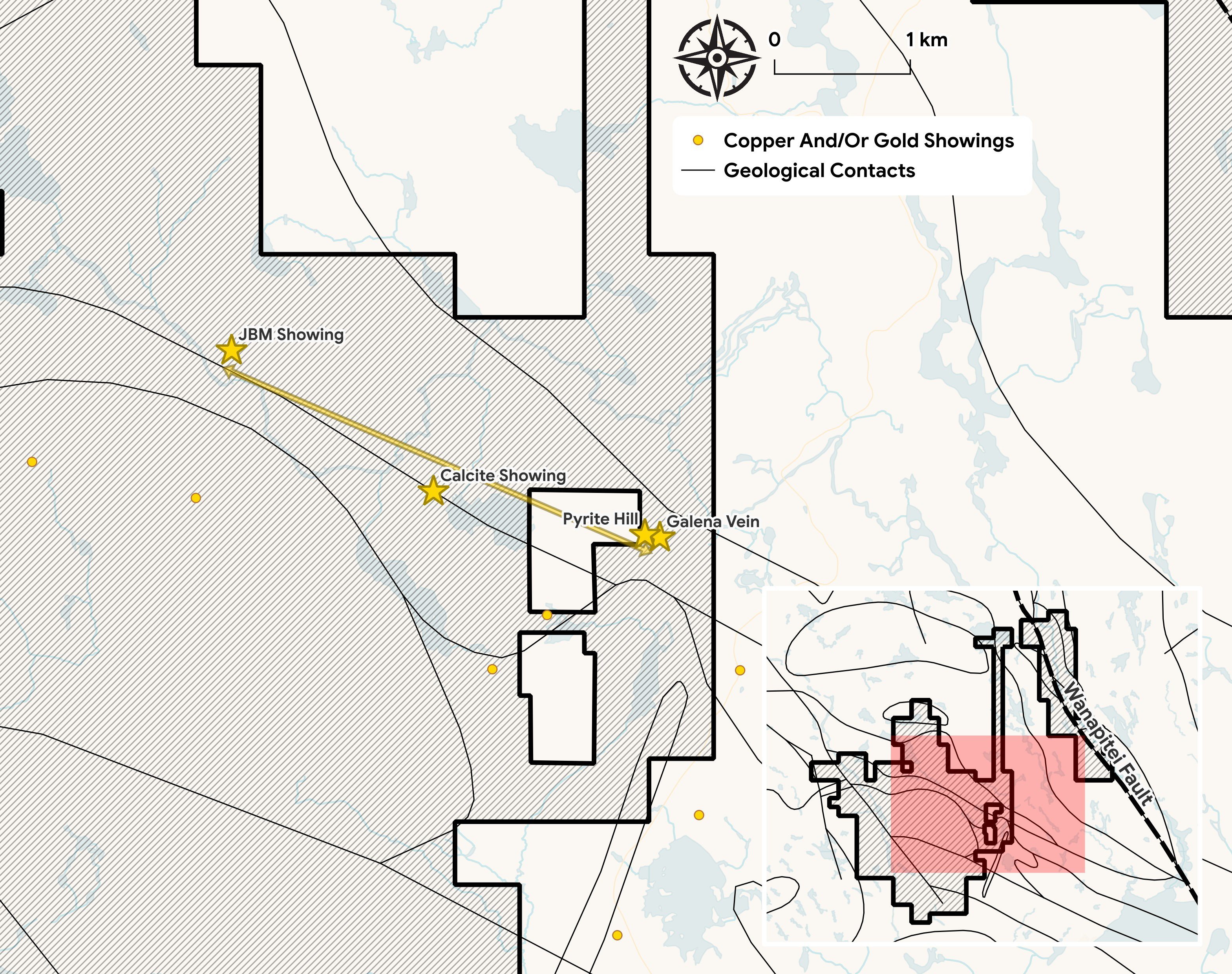
Four gold-copper-silver showings (Pyrite Hill/Galena, Calcite, JBM, McFie Lake) align along a 6 km NW corridor. A continuous 4 km IP chargeability anomaly links them, is open in both directions, and has never been drilled. At the marble quarry, magnetite-albite alteration is consistent with a MIAC system — the property's most direct physical evidence.
Pyrite Hill / Galena
High-grade gold at surface, directly over the untested IP anomaly on the contact. Select surface grab: 16.85 g/t Au, 28.8 g/t Ag, 0.59% Cu — with tellurium, a gold-system pathfinder, confirmed at surface.
The Same System, Stepped Out
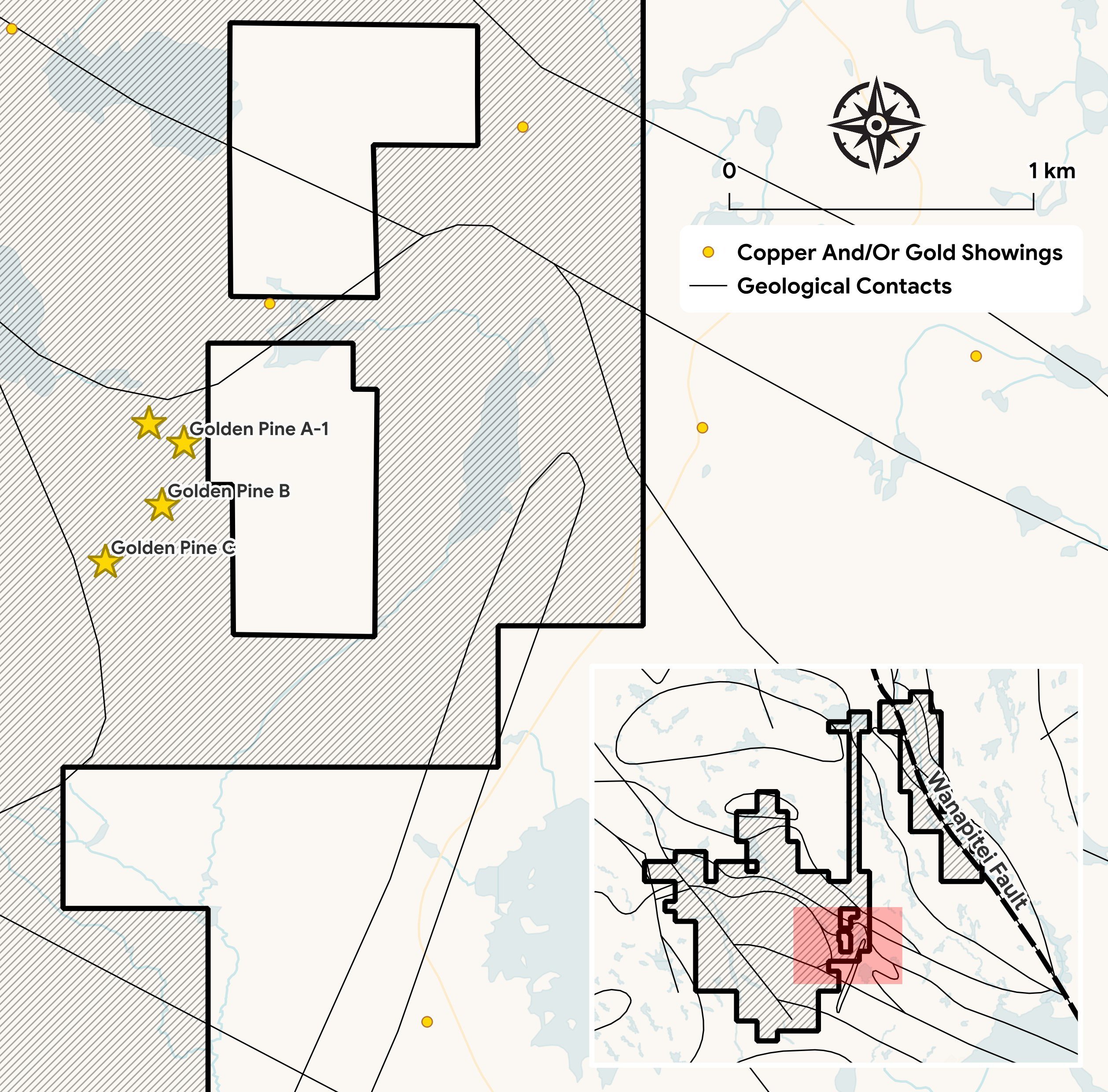
We interpret Golden Pine as the same gold system, stepped out along another splay of the Wanapitei structure — high-grade, and untested at depth.
- A ~150 m wide shear system in altered mafic to felsic volcanics with up to 40% disseminated pyrite — four mineralized zones, none drilled out.
- A 1 km IP anomaly extension to the northeast has never been drill-tested.
- Prior drilling was incorrectly positioned relative to the zones — the targets remain open.
Exploration Path
Vectoring to Drill Targets
Our program is sequenced to confirm the fault-driven system and convert it into drill-ready targets. Field work begins summer 2026, designed to generate steady updates toward a maiden drill program.
Confirm the System
- Ground sampling and structural mapping along the Wanapitei corridor and Marble Mountain contact.
- Ground gravity at River North to test for an iron-rich body at depth.
- VTEM over Marble Mountain to define conductors beneath the IP anomaly.
Define the Targets
- 3D inversion of existing IP, with infill lines to close coverage gaps.
- Channel sampling along the limestone contact, Pyrite Hill to Calcite.
- Integrate sampling, gravity, VTEM and IP into ranked, drill-ready targets.
Maiden Drill Program
- Integrate all sampling, geophysics and structural data collected to date into a ranked target list.
- Plan and permit a maiden drill program at the highest-priority targets defined by the work.
Exploration Path
Vectoring to Drill Targets
Our program is sequenced to confirm the fault-driven system and convert it into drill-ready targets. Field crews are on the ground as of summer 2026, with geophysical surveys to be completed in the coming months, designed to generate steady updates toward a maiden drill program.
Confirm the System
- Ground sampling and structural mapping along the Wanapitei corridor and Marble Mountain contact — field crews are now on the property.
- Ground gravity at North River to test for an iron-rich body at depth.
- VTEM over Marble Mountain to define conductors beneath the IP anomaly.
Define the Targets
- 3D inversion of existing IP, with infill lines to close coverage gaps.
- Channel sampling along the limestone contact, Pyrite Hill to Calcite.
- Integrate sampling, gravity, VTEM and IP into ranked, drill-ready targets.
Maiden Drill Program
- Integrate all sampling, geophysics and structural data collected to date into a ranked target list.
- Plan and permit a maiden drill program at the highest-priority targets defined by the work.
2026 Summer Program
Three Priority Areas, Now Active
Field crews are working three priority areas along the controlling structures, combining prospecting and sampling with ground gravity and airborne electromagnetic surveys.
Marble Mountain
- A corridor carrying gold, silver, copper and lead, with nickel and copper at the Calcite showing.
- Crews are mapping the corridor end to end and confirming each showing with channel samples cut across the zones.
- An airborne electromagnetic (VTEM) survey will follow the marble contact to identify sulphide conductors at depth — a strong conductor could mark a pod of sulphide-hosted gold and a compelling drill target.
Golden Pine
- Crews are re-sampling the historical Golden Pine gold zones and extending the soil grid along strike.
- At Malbeuf Lake, sampling targets a Sudbury offset dyke carrying nickel, copper and gold.
Black Creek
- Archean volcanic rocks of the Sudbury North Range.
- Crews are searching for the bedrock source of the Vermillion River placer gold, traced through till sampling.